![[Image]SANEI HYTECHS](/en/shared/img/logo_w.png)
[BLUE ECONOMY EXPO @ Suruga Bay] Supporting Inspection & Planning in Port & Marine Fields with 3D Models & Simulation
2026.09.15
- R&D
Visualization in port infrastructure inspection and planning is highly emphasized for aging countermeasures (asset management) of breakwaters quays and mooring facilities as well as port expansion and dredging plans. To appropriately maintain and manage infrastructure understanding facility conditions and linking to future plans is vital.
In recent years, the transition from traditional 2D drawings and visual inspections by divers to digital twins integrating 3D models (point cloud data) and fluid simulation is rapidly advancing.
Furthermore, combining 3D models with fluid analysis of wind, waves, and tidal currents enables the construction of simulation environments assuming actual sea areas.
On the other hand in field operations within the port and marine sectors
there are challenges such as these.
SANEI HYTECHS will exhibit at BLUE ECONOMY EXPO @ Suruga Bay held at Shimizu Marine Terminal on 22-23 October 2026.
At this exhibition, we will introduce "3D Seabed Topography Models" utilizing point cloud data and other spatial datasets, as well as "Fluid Dynamic Simulations" powered by open-source CFD (Computational Fluid Dynamics) software.
In this article, we will introduce the exhibition content and images of its application in the port and marine fields.
In recent years, the transition from traditional 2D drawings and visual inspections by divers to digital twins integrating 3D models (point cloud data) and fluid simulation is rapidly advancing.
Furthermore, combining 3D models with fluid analysis of wind, waves, and tidal currents enables the construction of simulation environments assuming actual sea areas.
On the other hand in field operations within the port and marine sectors
- Safety risks and field adjustment burdens associated with underwater structure inspections
- Difficulty in understanding sea areas complexly affected by topography structures and tidal currents
- Shortage of specialized personnel responsible for inspection and investigation
- Data processing and preparation man-hours required to build 3D models and simulation environments
there are challenges such as these.
SANEI HYTECHS will exhibit at BLUE ECONOMY EXPO @ Suruga Bay held at Shimizu Marine Terminal on 22-23 October 2026.
At this exhibition, we will introduce "3D Seabed Topography Models" utilizing point cloud data and other spatial datasets, as well as "Fluid Dynamic Simulations" powered by open-source CFD (Computational Fluid Dynamics) software.
In this article, we will introduce the exhibition content and images of its application in the port and marine fields.
4 Key Challenges in the Port and Marine Sectors
In marine sector operations, such as maintenance/management of port facilities and development of underwater robots, adaptation to environments different from land is required.
1. Burdens Associated with Underwater Inspection and Investigation
In inspections of underwater structures, divers and ROVs (Remotely Operated Vehicles) are utilized.
However, affected by sea conditions and weather, safety considerations are necessary for on-site work. Additionally, advance preparation, including arranging workers, equipment, and vessels, poses a burden.
Therefore, an environment where target locations and work methods can be checked before performing on-site work is demanded.
However, affected by sea conditions and weather, safety considerations are necessary for on-site work. Additionally, advance preparation, including arranging workers, equipment, and vessels, poses a burden.
Therefore, an environment where target locations and work methods can be checked before performing on-site work is demanded.
2. Difficulty in Understanding and Sharing Complex Sea Area Environments
In ports and coastal areas, in addition to structures such as quays and breakwaters, there is complex seabed topography.
Furthermore, affected by wind, waves, and tidal currents, understanding sea area conditions solely through 2D drawings or numerical values is not easy.
By utilizing 3D models and simulations, it becomes easier to share target sea area conditions even among stakeholders with different expertise.
Furthermore, affected by wind, waves, and tidal currents, understanding sea area conditions solely through 2D drawings or numerical values is not easy.
By utilizing 3D models and simulations, it becomes easier to share target sea area conditions even among stakeholders with different expertise.
3. Shortage of Specialized Personnel
Inspection of port facilities and operation of underwater robots require specialized knowledge and experience.
Amid challenges in securing talent, supporting on-site work and conducting preliminary reviews and training in digital environments are expected to lead to operational efficiency.
Amid challenges in securing talent, supporting on-site work and conducting preliminary reviews and training in digital environments are expected to lead to operational efficiency.
4. Costs Involved in Building 3D Models and Simulation Environments
To perform 3D simulation, it is necessary to combine multiple datasets such as land topography data and seabed depth data.
Aligning data formats and resolutions and processing them into 3D meshes usable for simulation require certain knowledge and work time.
SANEI HYTECHS is engaged in technical development ranging from such data processing to 3D model generation and application to simulation.
Aligning data formats and resolutions and processing them into 3D meshes usable for simulation require certain knowledge and work time.
SANEI HYTECHS is engaged in technical development ranging from such data processing to 3D model generation and application to simulation.
Technology Development Utilizing 3D Models and Simulation
In this exhibition, we will introduce technologies mainly from the following three perspectives.
1. Review and Formulation of Inspection/Investigation Plans Utilizing 3D Models
If target topography and structures can be confirmed on 3D models before conducting inspections or investigations in actual sea areas, work details and routes can be reviewed in advance.
For example assuming an investigation using an underwater robot:
such items can be confirmed in 3D space.
By relying not only on on-site work but performing preliminary reviews in digital environments, we support the review of inspection and investigation plans considering safety and work efficiency.
For example assuming an investigation using an underwater robot:
- Which locations to investigate
- Which routes to navigate
- What topography and structures exist in the surroundings
such items can be confirmed in 3D space.
By relying not only on on-site work but performing preliminary reviews in digital environments, we support the review of inspection and investigation plans considering safety and work efficiency.
2. Visualization Combining Topographic Data and Fluid Data
By overlaying not only topographic information but also information such as flow velocity from fluid analysis onto 3D models, sea area environments can be understood more specifically.
In this exhibition, we create 3D models of seabed topography utilizing point cloud data from VIRTUAL SHIZUOKA published by Shizuoka Prefecture and water depth data published by the Japan Coast Guard.
Furthermore, by combining fluid analysis, we visualize flow conditions in sea areas.
Such data can be applied not only to reviews of port and marine facilities but also to operation training of underwater robots and understanding flows in sea areas.
In this exhibition, we create 3D models of seabed topography utilizing point cloud data from VIRTUAL SHIZUOKA published by Shizuoka Prefecture and water depth data published by the Japan Coast Guard.
Furthermore, by combining fluid analysis, we visualize flow conditions in sea areas.
Such data can be applied not only to reviews of port and marine facilities but also to operation training of underwater robots and understanding flows in sea areas.
3. Preparation of 3D Data Connecting Land to Seabed
In simulations targeting ports and coastal areas, it is important to treat the entire target area as a single environment rather than handling land topography and seabed depth separately.
SANEI HYTECHS works on processing land topographic data published by the Geospatial Information Authority of Japan (GSI) and water depth data into 3D data usable for simulations.
It is also possible to create 3D models according to applications by providing data of target sea areas.
SANEI HYTECHS works on processing land topographic data published by the Geospatial Information Authority of Japan (GSI) and water depth data into 3D data usable for simulations.
It is also possible to create 3D models according to applications by providing data of target sea areas.
Exhibition Highlights
Creating Seabed Topography 3D Models from Point Cloud Data
One of the important elements in building a 3D simulation environment is topographic data.
Point cloud data contains numerous points representing shapes of topography and structures. By processing this data into 3D meshes according to applications rather than handling raw data, models that are easy to use for simulations can be created.
SANEI HYTECHS is advancing technical development to process various topographic data, including point cloud data, to generate 3D models.
Point cloud data contains numerous points representing shapes of topography and structures. By processing this data into 3D meshes according to applications rather than handling raw data, models that are easy to use for simulations can be created.
SANEI HYTECHS is advancing technical development to process various topographic data, including point cloud data, to generate 3D models.
Omaezaki Area Model Utilizing VIRTUAL SHIZUOKA Data
At last year's BLUE ECONOMY EXPO, we exhibited 3D models of coastal areas around Izu utilizing point cloud data from VIRTUAL SHIZUOKA.
This time, utilizing newly published 2026 data of the central-western coastal area from VIRTUAL SHIZUOKA, we reproduce seabed topography including Omaezaki as 3D models.
This time, utilizing newly published 2026 data of the central-western coastal area from VIRTUAL SHIZUOKA, we reproduce seabed topography including Omaezaki as 3D models.
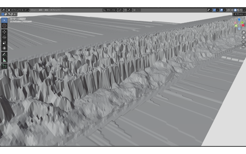
3D model of seabed around Omaezaki created from VIRTUAL SHIZUOKA point cloud data
Source:
VIRTUAL SHIZUOKA © Shizuoka Prefecture Processed and created by our company based on Creative Commons License (Attribution 4.0 International)
VIRTUAL SHIZUOKA © Shizuoka Prefecture Processed and created by our company based on Creative Commons License (Attribution 4.0 International)
- Source URL:https://virtualshizuokaproject.my.canva.site/
- Creative Commons:https://creativecommons.org/licenses/by/4.0/
Extending Models from Shimizu Port Area to Open Sea Areas
In addition to the demonstration field surroundings at Shimizu Port (the venue), looking ahead to future demonstration field expansions, we are creating 3D models for areas outside the port.
By combining GSI topographic data and 500m mesh water depth data published by the Japan Oceanographic Data Center, we create wide-area 3D models connecting land to the seabed.
By combining GSI topographic data and 500m mesh water depth data published by the Japan Oceanographic Data Center, we create wide-area 3D models connecting land to the seabed.
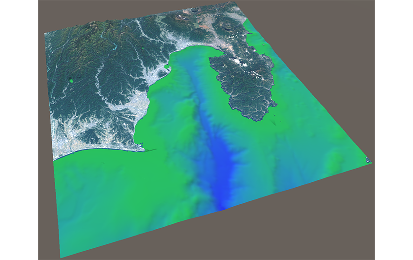
Integrated land-sea 3D model connecting Shimizu Port demonstration field to open sea area
Source:
Created by SANEI HYTECHS through independent processing the nationwide Landsat mosaic images and elevation tiles from the Geospatial Information Authority of Japan (GSI).
Created by SANEI HYTECHS through independent processing the nationwide Landsat mosaic images and elevation tiles from the Geospatial Information Authority of Japan (GSI).
- Source URL: https://www.gsi.go.jp/
- Data sources: Landsat 8 imagery (GSI, TSIC, GEO Grid/AIST), Landsat 8 imagery (courtesy of the U.S. Geological Survey), Bathymetry (GEBCO)
- Creative Commons: https://creativecommons.org/licenses/by/4.0/
- Source URL: https://www.jodc.go.jp/jodcweb/JDOSS/infoJEGG_j.html
Creating 3D Models Tailored to Target Areas
By providing point cloud data or water depth data of target sea areas or ports, we accommodate the creation of 3D models tailored to applications and target areas.
We also handle consultations such as wanting to utilize owned point cloud data as 3D models.
We also handle consultations such as wanting to utilize owned point cloud data as 3D models.
Fluid Dynamic Simulations Powered by Open-Source Software
At the previous BLUE ECONOMY EXPO, we exhibited an underwater drone operation simulation.
One of the feedbacks received at that time was:
Can fluid movements like wind and tidal currents be simulated in addition to topography?
which was requested.
In response to this feedback, we are currently working on expanding our underwater drone operation simulator by integrating fluid simulations using open-source CFD software.
In this exhibition, we introduce results of fluid analysis performed on 3D meshes assuming coastal areas, visualizing flow velocity distribution.
One of the feedbacks received at that time was:
Can fluid movements like wind and tidal currents be simulated in addition to topography?
which was requested.
In response to this feedback, we are currently working on expanding our underwater drone operation simulator by integrating fluid simulations using open-source CFD software.
In this exhibition, we introduce results of fluid analysis performed on 3D meshes assuming coastal areas, visualizing flow velocity distribution.
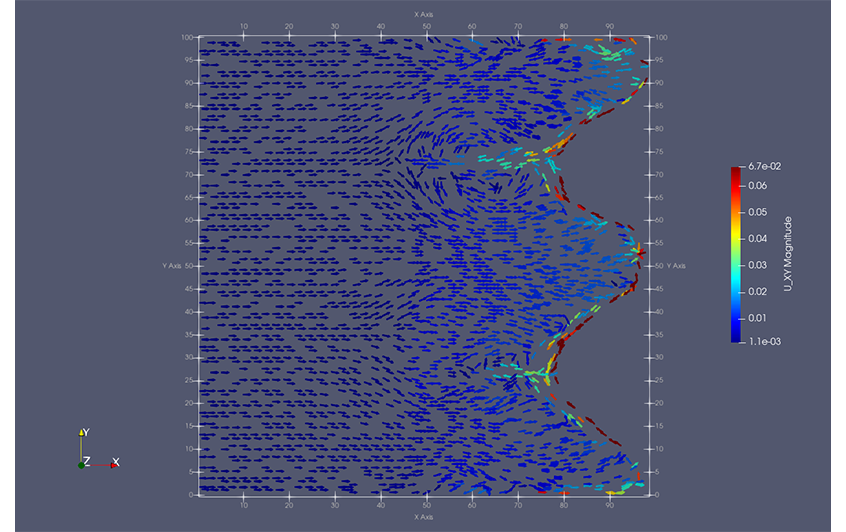
Flow velocity distribution of rip currents by fluid simulation
By combining topographic 3D models with fluid analysis, simulation environments including sea area flows can be constructed rather than merely viewing topography.
In the future, we will consider applications to various uses such as operation training of underwater robots and preliminary reviews of sea area investigations.
In the future, we will consider applications to various uses such as operation training of underwater robots and preliminary reviews of sea area investigations.
Experience 3D Models and Simulation Live at the Venue
At our booth, we plan the following exhibits so you can specifically understand the technologies introduced this time.
Poster Exhibition
We will introduce the step-by-step process of creating 3D models from point cloud data, the results of our fluid dynamic simulations, and various practical use cases.
Video & 3D App Exhibition
You can view 3D models around the Shimizu Port demonstration field and fluid simulation conditions via videos and 3D apps.
We plan exhibits where you can check topographic shapes and flow conditions while operating in 3D space.
Additionally, technical staff will handle individual consultations at the venue.
- Can this sea area be modeled in 3D?
- Wanting to utilize owned point cloud data
- Wanting to build a training environment for underwater robots
If you have specific consultations like these, please feel free to ask us.
We plan exhibits where you can check topographic shapes and flow conditions while operating in 3D space.
Additionally, technical staff will handle individual consultations at the venue.
- Can this sea area be modeled in 3D?
- Wanting to utilize owned point cloud data
- Wanting to build a training environment for underwater robots
If you have specific consultations like these, please feel free to ask us.
BLUE ECONOMY EXPO @ Suruga Bay Exhibition Outline
| Event Name | BLUE ECONOMY EXPO @ Suruga Bay |
|---|---|
| Dates | 22-23 October 2026 |
| Venue | Shimizu Marine Terminal [Booth Number:S-11] 10-80 Hinode-cho Shimizu-ku Shizuoka-shi Shizuoka |
| Exhibiting Company | SANEI HYTECHS Co. Ltd. |
| Official Website | https://blue-economy-expo.jp/blue-ocean-expo/ |
If you are interested in utilizing 3D data and simulations in the marine sector, please drop by our booth.
While listening to challenges you feel in actual operations and development, we hope to explore with our technical staff how 3D models and simulations can be utilized.
While listening to challenges you feel in actual operations and development, we hope to explore with our technical staff how 3D models and simulations can be utilized.
Technical Consultations & Inquiries
- Wanting to converting owned point cloud data into 3D
- Wanting to build simulation environments targeting specific ports/sea areas
- Wanting to consult on operation and verification environments for underwater robots
We accept inquiries and technical consultations regarding exhibit content such as these.
Not limited to the marine sector, when considering the utilization of 3D data and simulation, please feel free to consult with us.
- Wanting to build simulation environments targeting specific ports/sea areas
- Wanting to consult on operation and verification environments for underwater robots
We accept inquiries and technical consultations regarding exhibit content such as these.
Not limited to the marine sector, when considering the utilization of 3D data and simulation, please feel free to consult with us.