![[Image]SANEI HYTECHS](/en/shared/img/logo_w.png)
Robot Development — Autonomous Navigation Technology Utilizing ROS2 and LiDAR
We are engaged in the research and development of autonomous mobile robots for outdoor rough terrain environments. With a focus on deployment in fields such as agriculture and logistics where labor shortages are a pressing challenge, we are working toward the realization of a robot system capable of stable travel even in uneven terrain. From hardware design and fabrication to software development utilizing ROS2, verification in a HILS environment, and driving demonstrations on actual machines, we are advancing technology development through an integrated development structure.

Seamless Development System
INDEX
- Our Robot Development Project
- Autonomous Mobile Robot Development
- Simulation Environment Utilizing HILS
- Development of Obstacle Detection Technology Using LiDAR (Point Cloud Data Analysis)
- Application Fields for Autonomous Mobile Robots
- Technologies and Development Achievements
- Direction of Technology Development
- Inquiries Regarding Robot Development and Automation
Our Robot Development Project
For an autonomous mobile robot to operate safely and reliably, three key capabilities are essential: "accurately determining its current position," "generating an appropriate route to the destination and traveling along it," and "detecting surrounding obstacles." To address these challenges, we are advancing our robot development project with the following two areas of technology development as its core pillars.
Autonomous mobile robot development (self-localization and navigation)
Development of obstacle detection technology using LiDAR (point cloud data analysis)
Autonomous Mobile Robot Development
System Architecture Utilizing ROS2
Our autonomous mobile robot software is built on ROS2 as its foundation. The robot and a remote control PC are connected via Wi-Fi, enabling real-time control. Each function is implemented as an independent program called a node, and we have adopted a highly scalable system architecture that flexibly accommodates the addition or modification of functions.
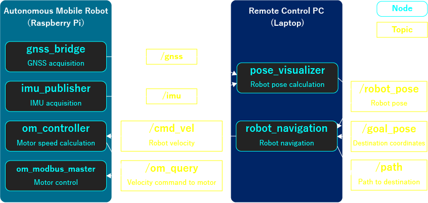
Autonomous Navigation System Configuration Using ROS2
Self-Localization Using RTK-GNSS and IMU
Accurate self-localization is one of the most critical technologies for autonomous navigation in outdoor environments. We have developed a system that combines GNSS (Global Navigation Satellite System) and IMU (Inertial Measurement Unit) to acquire the robot's position and orientation in real time. Furthermore, by adopting RTK-GNSS utilizing electronic reference points, we have achieved high-precision position estimation at the centimeter level — a level of accuracy that is difficult to attain with conventional GPS. The acquired position and orientation data can be visualized in real time on rviz2, contributing to greater efficiency in development and verification workflows.
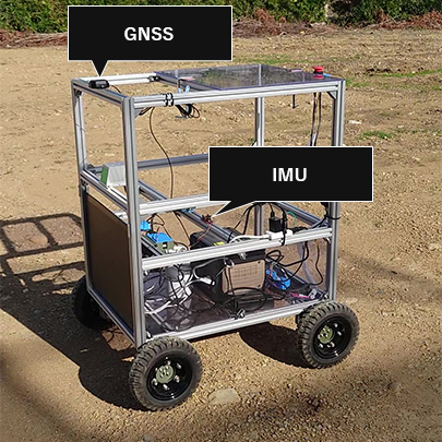
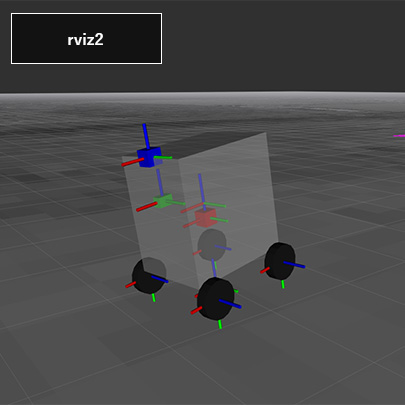
Acquiring Robot Pose and Orientation Data
Development of Navigation Functionality
We are developing a navigation function that automatically generates a route to the destination and travels along it. By designing the route generation algorithm and route tracking algorithm independently, we have adopted a configuration that allows each to be improved flexibly. In driving demonstrations conducted on actual rough terrain, we successfully achieved autonomous navigation to the destination while avoiding designated no-entry zones, confirming the effectiveness of our navigation technology in outdoor environments.
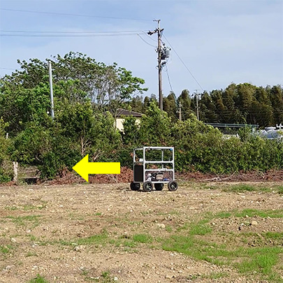
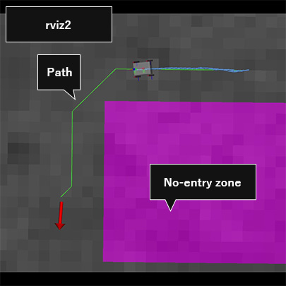
Autonomous Navigation in Rough Terrain
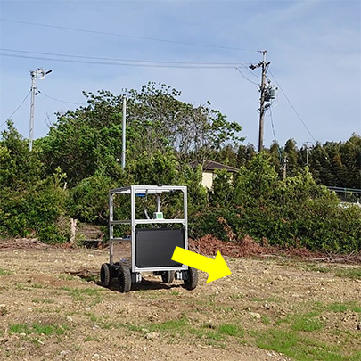
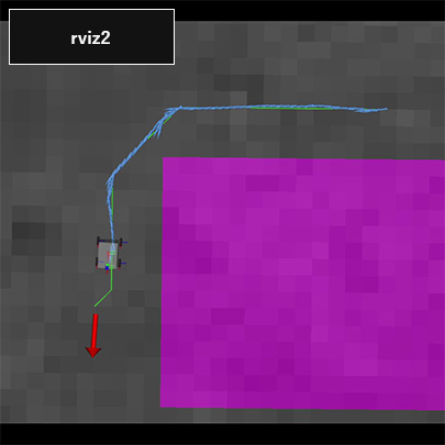
Avoiding Designated No-Entry Zones
Simulation Environment Utilizing HILS
Building a HILS Environment with Unity
In robot development, repeatedly verifying algorithms using only actual hardware requires considerable time and cost.
We have independently built a HILS (Hardware In the Loop Simulation) environment (※) on Unity that faithfully reproduces the actual robot and its operating environment. The key feature of this HILS environment is that the ROS2 software running on the actual hardware can be used as-is. Since verification can be performed in both the simulation environment and the actual hardware environment without any software modifications, we have achieved a shorter development cycle and improved quality.
We have independently built a HILS (Hardware In the Loop Simulation) environment (※) on Unity that faithfully reproduces the actual robot and its operating environment. The key feature of this HILS environment is that the ROS2 software running on the actual hardware can be used as-is. Since verification can be performed in both the simulation environment and the actual hardware environment without any software modifications, we have achieved a shorter development cycle and improved quality.
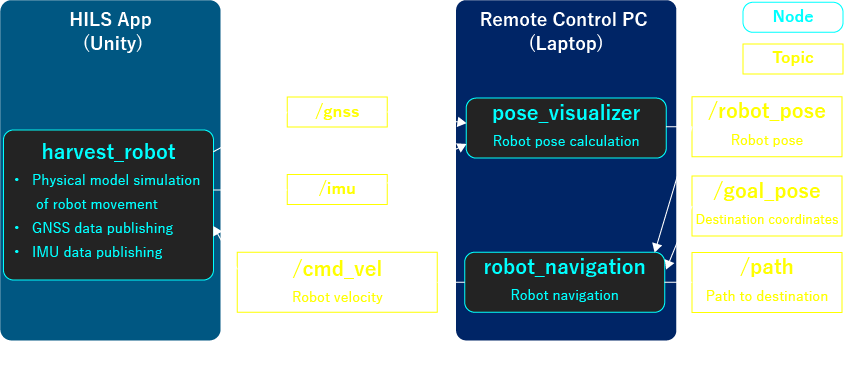
Overview of the HILS Environment
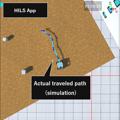
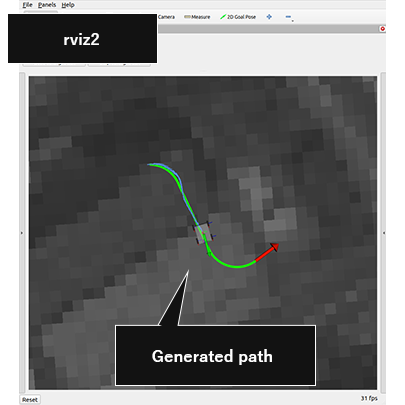
Navigation Functionality Running in the HILS Environment
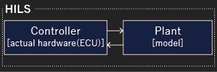
※HILS (Hardware In the Loop Simulation) is a simulation method used in model-based development.
This is a simulation method that combines an actual hardware controller (ECU) with a software-based plant model. The plant model receives control commands from the controller, and its responses are fed back to the controller, enabling safe and efficient testing that reproduces real-world conditions.
We also offer model-based development as part of our business services. For more details, please refer to our business overview below.
Development of Obstacle Detection Technology Using LiDAR (Point Cloud Data Analysis)
Development of the Box-Shaped Stop Algorithm
For an autonomous mobile robot to navigate safely, a mechanism to detect surrounding obstacles in real time and respond appropriately is essential. We have independently developed an obstacle detection technology using LiDAR called the "box-shaped stop algorithm." This technology sets a cubic detection zone called a stop zone in the robot's direction of travel, and executes a stop sequence when an obstacle is detected within that zone.
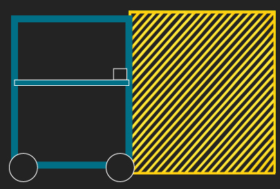
Schematic Diagram of the Robot and Stop Zone
This algorithm detects obstacles and executes a stop sequence through the following processes.
- Acquiring point cloud data in front of the robot using LiDAR
- Removing ground point cloud data using a plane detection algorithm
- Determining whether an obstacle exists within the configured stop zone
- Executing a stop sequence upon detection of an obstacle
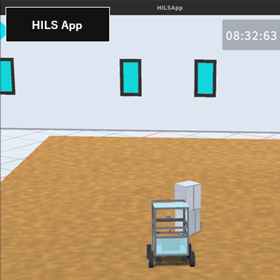
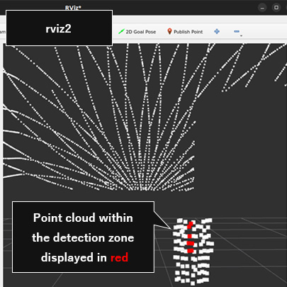
Obstacle Detection in the HILS Environment
※Ground point cloud has been removed
※Ground point cloud has been removed
This technology is currently being utilized as a safety stop function during navigation, and we are also exploring its future application in route generation for obstacle avoidance.
Application Fields for Autonomous Mobile Robots
Automated Travel in Agricultural Settings
By automating material transport and patrol operations within agricultural fields, reduced workload and labor savings are expected. The ability to travel stably in uneven terrain is a key requirement for agricultural robots.
Transport Automation in Logistics
By automating transport operations in factories and logistics facilities, we contribute to improved operational efficiency and addressing labor shortages. Autonomous navigation technology can serve as the foundational technology for transport robots and AMRs (Autonomous Mobile Robots).
Automation of Outdoor Inspection Operations
By utilizing robots for inspection of facilities and infrastructure, patrols across wide areas and in hazardous locations can be made more efficient. Environmental recognition technology using LiDAR is a critical technology supporting safe autonomous mobility.
Autonomous Navigation Support at Construction Sites
At construction sites, there are growing expectations for the use of robots in material transport and patrol operations in uneven terrain environments. Technology capable of stable travel on rough terrain and slopes is also highly effective in the construction sector.
Technologies and Development Achievements
In this project, we have consistently driven the entire development process — from robot chassis design and fabrication to software development utilizing ROS2, simulation in a HILS environment, and driving demonstrations on actual hardware. Through a development structure that combines hardware and software, we are advancing technology development toward the practical application of autonomous mobile robots in outdoor environments. Furthermore, through driving demonstrations on actual rough terrain, we have accumulated verification of our navigation functions and obstacle detection technology, advancing the sophistication of our autonomous navigation technology in outdoor uneven terrain environments.
Technologies
- Robot chassis design and fabrication
- Robot software development using ROS2
- Self-localization utilizing RTK-GNSS and IMU
- Navigation algorithm development
- Simulation environment construction using HILS
- Point cloud data processing and obstacle detection using LiDAR
- Driving demonstrations and evaluation on actual hardware
Development Achievements
- Demonstration of autonomous navigation on rough terrain
- Realization of navigation with consideration for no-entry zones
- Construction of a development and verification environment integrating HILS and actual hardware
- Implementation of obstacle detection and safety stop functionality utilizing LiDAR
Direction of Technology Development
Building on our current research achievements, we are advancing technology development toward the realization of a more sophisticated autonomous mobility system.
- Development of detour route search functionality upon obstacle detection
- Research and development of 3D-SLAM technology
Inquiries Regarding Robot Development and Automation
We leverage the technologies and expertise cultivated through our research and development of autonomous mobile robots to address a wide range of inquiries in the field of robotics. If you are considering technology utilization, joint research, or technical verification, please feel free to contact us.
* The map displayed on rviz2 was created by our company using the GSI Tiles (Seamless nationwide latest aerial photography) provided by the Geospatial Information Authority of Japan (https://maps.gsi.go.jp/development/ichiran.html).