
Blue Ocean Expo @ Suruga Bay
SANEI HYTECHS Co., Ltd. will exhibit at "Blue Ocean EXPO @ Suruga Bay," held from Thursday, October 22 to Friday, October 23, 2026. In this exhibition, we will introduce 3D visualization of seabed topography and fluid simulation for underwater drones as technologies related to the survey of port and marine infrastructure. In the 3D visualization of seabed topography, we recreate the topography of the seabed and surrounding port areas as 3D models based on point cloud data. We have built an environment that allows you to check the terrain and surrounding conditions before conducting on-site surveys. In the fluid simulation for underwater drones, we simulate movement underwater taking the effects of water currents into account. At the exhibition, we will introduce this through videos. In surveys and inspections, in addition to on-site checks, it is also important to understand the surrounding conditions in advance. In this exhibition, we will introduce methods for using 3D data and simulations to assess site conditions prior to conducting surveys and inspections.
Exhibition Overview
| Event Name | Blue Ocean EXPO @ Suruga Bay https://blue-economy-expo.jp/ |
|---|---|
| Dates & Times | 22-23 October 2026, 10:00–17:00 |
| Venue | Shimizu Marine Terminal 2nd Floor, Multipurpose Hall 【Booth Number: S-11】 10-80 Hinode-cho, Shimizu-ku, Shizuoka City |
Exhibition Highlights & Contents
The contents of this exhibition focus on the following two themes:
Both are visualization technologies designed to understand marine sites in advance.
For the 3D visualization of seabed topography, we are preparing an interactive demo where you can actually navigate through the 3D space. You can experience how data is visualized while examining the seabed and port topography in a 3D model. For the fluid simulation for underwater drones, we will introduce how simulations take water currents into account via video. You can see how water currents affect the movements of underwater drones.
*Interactive demos of fluid simulation for underwater drones may be conducted depending on preparation status.
- 3D visualization of seabed topography
- Fluid simulation for underwater drones
Both are visualization technologies designed to understand marine sites in advance.
For the 3D visualization of seabed topography, we are preparing an interactive demo where you can actually navigate through the 3D space. You can experience how data is visualized while examining the seabed and port topography in a 3D model. For the fluid simulation for underwater drones, we will introduce how simulations take water currents into account via video. You can see how water currents affect the movements of underwater drones.
*Interactive demos of fluid simulation for underwater drones may be conducted depending on preparation status.
3D Visualization of Seabed Topography (With Interactive Demo Exhibit)
Recreating seabed and port topography in 3D using point cloud data. In this exhibition, coastal topography is recreated using 3D point cloud data from "VIRTUAL SHIZUOKA" published by Shizuoka Prefecture. Furthermore, by combining the 500m mesh bathymetric data published by the Japan Coast Guard with elevation data from the Geospatial Information Authority of Japan, we constructed a 3D space that includes the seabed topography along the Shizuoka coast. You can freely navigate within the 3D space to examine seabed undulations and their positional relationship with surrounding port areas. Checking seabed topography prior to on-site surveys serves as valuable reference information when considering survey locations and methods. At the venue, in addition to poster and video presentations, we will showcase an interactive demo where you can actually navigate within the 3D space. You can experience how seabed topography is visualized while freely moving around in the 3D space.
Reproducing detailed coastal terrain using data from "VIRTUAL SHIZUOKA"
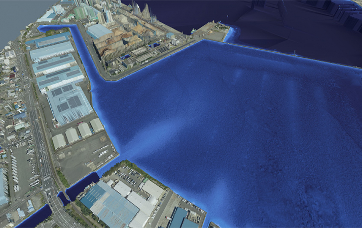
Source: Processed and created by our company based on VIRTUAL SHIZUOKA © Shizuoka Prefecture Creative Commons License (CC BY 4.0)
Source URL: https://virtualshizuokaproject.my.canva.site/
Creative Commons: https://creativecommons.org/licenses/by/4.0/
Source URL: https://virtualshizuokaproject.my.canva.site/
Creative Commons: https://creativecommons.org/licenses/by/4.0/
Integrating 500m mesh bathymetric data published by the Japan Coast Guard with elevation data from the Geospatial Information Authority of Japan
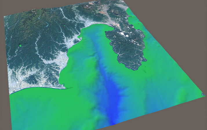
Integrating 500m mesh bathymetric data published by the Japan Coast Guard with elevation data from the Geospatial Information Authority of Japan into a single model
Source: Processed and created uniquely by our company based on national Landsat mosaic images and elevation tiles from the Geospatial Information Authority of Japan
Source URL: https://www.gsi.go.jp/ | Data Source: Landsat 8 images (GSI, TSIC, GEO Grid/AIST), Landsat 8 images (courtesy of the U.S. Geological Survey), Bathymetry (GEBCO)
Creative Commons: https://creativecommons.org/licenses/by/4.0/
Processed and created uniquely by our company based on 500m mesh bathymetric data from the Japan Oceanographic Data Center
Source URL: https://www.jodc.go.jp/jodcweb/JDOSS/infoJEGG_j.html
Source URL: https://www.gsi.go.jp/ | Data Source: Landsat 8 images (GSI, TSIC, GEO Grid/AIST), Landsat 8 images (courtesy of the U.S. Geological Survey), Bathymetry (GEBCO)
Creative Commons: https://creativecommons.org/licenses/by/4.0/
Processed and created uniquely by our company based on 500m mesh bathymetric data from the Japan Oceanographic Data Center
Source URL: https://www.jodc.go.jp/jodcweb/JDOSS/infoJEGG_j.html
Fluid simulation for underwater drones
When operating underwater drones in the ocean, water currents affect the drone's posture and navigation. Therefore, when planning actual operations, taking water currents into consideration becomes crucial. Our company is working on fluid simulations utilizing open-source CFD software.
In this exhibition, we will present video demonstrations of fluid simulations in a 3D space constructed based on actual terrain. You can observe how underwater currents change depending on water flow. Through posters and videos, we will introduce how fluid simulation can be utilized when planning the design and operation of underwater drones.
*Interactive demos may be conducted depending on preparation status.
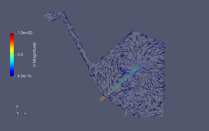
As an example, we will present the results of fluid simulation in the Port of Shimizu, where our demonstration field is deployed.
*Interactive demos may be conducted depending on preparation status.
As an example, we will present the results of fluid simulation in the Port of Shimizu, where our demonstration field is deployed.
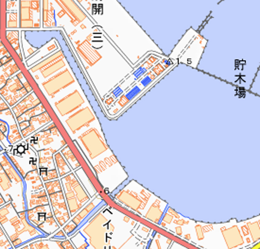
Shimizu Port
Source: Geospatial Information Authority of Japan (https://maps.gsi.go.jp/development/ichiran.html) GSI Tiles (Standard Map)
Analysis Results (Flow Velocity Distribution)
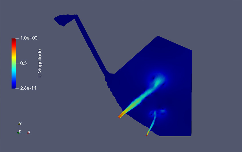
Analysis Results (Flow Velocity Vector Diagram)
Announcement of Presentation
During the exhibition, we will take the stage for an exhibitor presentation. We also plan to speak about our initiatives regarding 3D seabed visualization and fluid simulation for underwater drones introduced at our booth. Please feel free to join us.
| Date & Time | 22 October 2026, 14:30–14:55 |
|---|---|
| Location | Shimizu Marine Terminal Venue 2F, Sub-stage |
Feel Free to Consult with Us Regarding Surveys and Inspections
On the day of the exhibition, our technical staff will explain the exhibits.
You can consult with us on the technologies presented, such as 3D models of seabed topography and fluid simulations for underwater drones.
Furthermore, you can also consult with us if you wish to apply 3D data or simulations to surveys and inspections outside of marine applications.
Please share with us at the venue any challenges you face in the field or how you might utilize your existing data.
We look forward to welcoming you to our booth.
You can consult with us on the technologies presented, such as 3D models of seabed topography and fluid simulations for underwater drones.
Furthermore, you can also consult with us if you wish to apply 3D data or simulations to surveys and inspections outside of marine applications.
Please share with us at the venue any challenges you face in the field or how you might utilize your existing data.
We look forward to welcoming you to our booth.